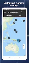
The PH Weather and Earthquakes app is your comprehensive source for real-time weather and seismic activity updates in the Philippines. Leveraging data from PAGASA's Project NOAH and PHIVOLCS, the app delivers current weather forecasts, earthquake alerts, tsunami warnings, and volcanic activity reports. Its functionality extends beyond the Philippines, offering a global earthquake list based on U.S.G.S. data.
The app also provides a suite of monitoring tools, including Doppler radar, various sensor readings (stream gauge, rain gauge, tide level, weather station), and detailed hazard maps for floods, landslides, and storm surges. For emergencies, built-in tools such as a flashlight and compass are readily available. Further features include weekly and hourly weather forecasts, a moon phase calendar, and integration with PHIVOLCS Fault Finder and LAVA. User feedback is welcomed via the app's official Facebook page.
Key Features of the PH Weather and Earthquakes App:
-
Weather Information: Receive up-to-the-minute weather updates from PAGASA's Project NOAH, encompassing 4-hour and 4-day forecasts. Stay informed about cyclones, typhoons, hurricanes, and other severe weather events.
-
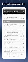
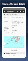
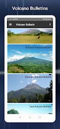
Seismic and Volcanic Activity: Stay abreast of earthquake, tsunami, and volcanic activity alerts from PHIVOLCS. Receive prompt notifications to ensure your safety during natural disasters.
-
Monitoring Capabilities: Access a variety of monitoring tools, including Doppler radar and sensor data (stream gauge, rain gauge, tide level, weather station), providing a detailed picture of current conditions.
-
Hazard Mapping: Utilize detailed hazard maps pinpointing flood, landslide, and storm surge risk areas, facilitating informed travel and evacuation planning.
-
Emergency Toolkit: Prepare for emergencies with essential tools like a flashlight, strobe light, siren, and compass, all conveniently integrated within the app.
-
Additional Resources: Explore supplementary features such as MT Satellite imagery and videos, Ovitrap (dengue) reports, government Twitter feeds, a critical facilities directory, and a moon phase calendar.
In Conclusion:
The PH Weather and Earthquakes app empowers users with the knowledge and tools necessary for preparedness. By providing real-time weather updates, earthquake alerts, and volcanic activity information, along with monitoring tools and hazard maps, the app enhances safety during natural disasters. The inclusion of emergency tools and supplementary features creates a comprehensive resource for weather awareness and disaster preparedness. Download the app today and proactively manage your safety in the face of unpredictable weather and natural events.

![https://images.ydeng.com[db:image]](https://images.ydeng.com[db:image])