Home Apps Productivity ShipAtlas by Maritime Optima
ShipAtlas by Maritime Optima

ShipAtlas by Maritime Optima

4.4
Application Description
ShipAtlas, developed by Maritime Optima, is an indispensable tool for anyone involved in vessel tracking or maritime operations. Leveraging real-time AIS data from over 700 satellite and terrestrial sources, it offers comprehensive vessel tracking capabilities and valuable insights into global maritime activities. This includes trade details, port operations, sea routes, marine weather forecasts, ice conditions, piracy risk areas, and detailed marine charts. The app processes raw AIS data from the global merchant fleet every second, ensuring high-data quality and accuracy. Its functionality extends to vessel and port searches, sea route calculations, customizable vessel lists, notification settings, daily marine updates, and much more. A user-friendly interface, cross-device data synchronization, and dedicated support are also key features.

Key Features of ShipAtlas:

  • Complete Maritime Data: Access detailed information on port activities, shipping lanes, weather patterns, ice conditions, piracy hotspots, and nautical charts.

  • High-Precision Data: Rigorous data processing ensures the accuracy and reliability of the AIS data presented.

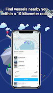
  • Advanced Vessel Search: Locate vessels using names, IMO or MMSI numbers, or port details. Refine searches with criteria such as length, beam, draft, and year of construction.

  • Sea Route Optimization: Quickly calculate estimated times of arrival, distances (nautical miles), time at sea, and projected fuel consumption for various routes.

  • Personalized Tracking: Create unlimited custom vessel lists based on your search parameters and monitor their movements in real time on the integrated map.

Summary:

ShipAtlas by Maritime Optima is a highly intuitive application providing real-time AIS position data and extensive maritime information. Its combination of high-quality data, user-friendly design, and powerful features like the sea route calculator makes it an invaluable asset for maritime professionals and enthusiasts. While many features are free, a paid subscription unlocks additional capabilities. Download ShipAtlas today to explore the world of maritime navigation and data. Learn more on our website.

Screenshot
  • ShipAtlas by Maritime Optima Screenshot 0
  • ShipAtlas by Maritime Optima Screenshot 1
  • ShipAtlas by Maritime Optima Screenshot 2
Reviews Post Comments
Latest Articles
  • Best LEGO Sets for 2025 Unveiled

    ​With hundreds of LEGO sets available, even the most dedicated fans will only build a fraction of them. Display space is one limiting factor, while pricing is another. For the investment required, the finished model should fully justify both the cost

    by Elijah Jan 09,2026

  • New Fire Emblem Titles Set for Nintendo Switch and Switch 2 in 2025

    ​Marking 35 years since Intelligent Systems launched the Fire Emblem series on Nintendo's Famicom, the franchise has grown into a cornerstone of tactical RPGs. Its evolving combat and deep character-bo

    by George Jan 09,2026

Latest Apps