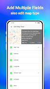
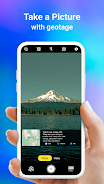
The GPS Map Camera App seamlessly integrates camera functionality with GPS location tracking. Its geotagging, GPS scanning, and mapping features enable users to create visually rich travel logs. The app boasts a powerful mapping system for viewing photos geographically, and allows users to add GPS location data to existing photos, effortlessly building a photo map of their adventures. Its intuitive design ensures seamless compatibility with GPS-enabled devices. Whether a professional photographer or casual shutterbug, the GPS Map Camera App is ideal for geotagging photos.
The GPSMapCameraApp offers six key advantages:
- Integrated Camera and GPS: Capture photos and instantly geotagg them with precise location data, creating a visual travel journal.
- Versatile Photo Capture and Tracking: Use the built-in GPS camera or add geotagging data to existing photos.
- Robust Mapping System: Easily view photos on a GPS map, visualizing their location along your route.
- Customizable Date and Timestamps: Choose and add preferred date and timestamp formats to your photos.
- Customizable Photo Management: Save photos with custom names and utilize live navigation for effortless organization.
- Lightweight Option Available: The Lite version provides many core features while minimizing device storage usage.


